General description
We proposed a specific point recognition problem related to the accurate location of specific human body landmarks used in manual anthropometry that are usually recognized by experienced operators by palpation.
Dataset creation
Models were originally acquired during standard antrhpometric analysis in the Department of Neurological and Movement Science, University of Verona with a structured light 3D body scanner (Breuckmann BodyScan). In the original textured models, anthropometric landmarks are visible as white crosses on the skin texture, marked with a dermographic pen.
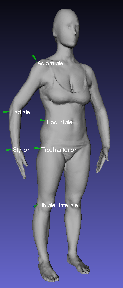
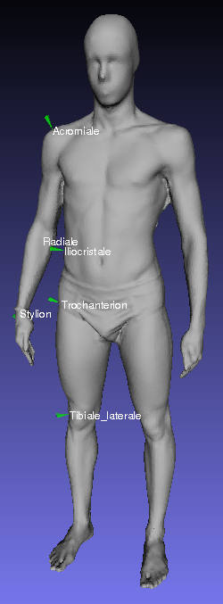
For the recognition task we selected six landmarks located in the right part of the body (Acromiale, Radiale, Stylion, Iliocristale, Trochanterion, Tibiale laterale, see figure on the left)
Models have been preprocessed in order to
- remove floor and noise,
- obtain watertight models with approximately 50000 faces
- oversmooth faces to avoid subjects recognition
- Map the coordinate system of models in order to have the origin of the x axis approximately in the center of the model. This is done in order to avoid ambiguities due to the body symmetry: we will then ask participants to find points with x < 0.
Annotations. Training and test data
For each model and for each of the six points we stored the triangle mesh in ply format
download example , a simple text file with extension ".pts" storing the xyz coordinates, the index of the closest vertex, the index of the closest triangle
download example . We also provide a ".pp" that can be loaded for simple visualization in the pick point tool of Meshlab
download example .
A total of 100 models was divided in a
training set that can now be downloaded and that includes 50 models with associated .pts and .pp files, and a
test set of 50 models provided to participants without ground truth annotations, that are now available in the file
test_gt.zip
Evaluation and SHREC 14 paper
For all the automatically annotated point sets submitted, we estimated Geodesic distances of extracted points, added to the meshes, from the manually annotated corresponding ones will be computed, and computed different validation measurements:
- Percentage of correctly labelled closest nodes and faces
- Average geodesic distances between corresponding points
- False negative error vs geodesic radius (considering correctly detected landmarks only within this distance from the target)
Results are reported in the paper
A. Giachetti, E. Mazzi, F. Piscitelli, M. Aono, A. Ben Hamza, T. Bonis, P. Claes, A. Godil, C. Li, M. Ovsjanikov, V. Patraucean, C. Shu, J. Snyders, P. Suetens, A. Tatsuma, D. Vandermeulen, S. Wuhrer1, P. Xi "SHREC’14 Track: Automatic Location of Landmarks used in Manual Anthropometry" - proc. Eurographics Workshop on 3D Object Retrieval (2014)
If you use these data for research purposes please cite this reference.
Contacts
Andrea Giachetti - Department of Computer Science, University of Verona
andrea.giachetti(at)univr.it
Francesco Piscitelli - Department of Neurological and Movement Science, University of Verona


